


Google Earth Images Show Hezbollah Building New Bases
Error: Contact form not found.

 by JNS.org

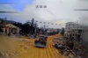
An image from Google Earth showing what is suspected to be a driver training course and other Hezbollah facilities. Photo: Google Earth.
Hezbollah has been building new bases and facilities in southern Lebanon and in the eastern Bekaa Valley near the Syrian border, the Lebanese Daily Star reported Tuesday, basing the report on recently uploaded Google Earth satellite images.
According to imagery analysts and European intelligence officials quoted by the Daily Star, the images show what appears to be a Hezbollah training base in an area of secluded hills near the border with Syria. The base includes what is suspected to be a driving course, a 100-meter firing range and a possible urban terrain assault course. The experts also indicated that the training base began construction in 2006, the year Hezbollah engaged in a war with Israel.
The images also showed a great deal of overt construction activity in Hezbollah-dominated areas in southern Lebanon, particularly in hills south of the town of Jezzine, which served as the terrorist organization’s main line of defense after the 2006 Second Lebanon War, the report said.
Hezbollah’s construction activity suggests the organization has made efforts to prepare for another possible confrontation with Israel.