


The Perils of ‘Palestine’ in Pictures
Error: Contact form not found.

 by Martin Sherman

Drone shot of area near Qalqilya in the West Bank. Photo: Israel Institute for Strategic Studies.
“If a Palestinian state is established, it will be armed to the teeth. Within it there will be bases of the most extreme terrorist forces, equipped with anti-tank and anti-aircraft shoulder-launched rockets, which will endanger not only random passers-by, but every airplane and helicopter taking off in the skies of Israel and every vehicle traveling along the major traffic routes in the coastal plain…[T]he frontiers of the Palestinian state will constitute an excellent staging point for mobile forces to mount attacks on infrastructure installations vital for Israel’s existence, to impede the freedom of action of the Israeli air-force in the skies over Israel, and to cause bloodshed among the population…in areas adjacent to the frontier-line…”
— Shimon Peres, Tomorrow is Now, Keter Publishers, 1978, pp 232, 255.
“…Israel, small and exposed, will neither be able to exist nor to prosper if its urban centers, its vulnerable airport and its narrow winding roads, are shelled. This is the fundamental difference between them and us, this is the terrible danger involved in the establishment of a third independent sovereign state between us and the Jordan River.”
— Amnon Rubinstein, “The Pitfall of a Third State,” Ha’aretz, August 8, 1976.
These two citations encapsulate, with chilling accuracy, the deadly dangers to which Israel would be exposed if a Palestinian state were to be established on the commanding hills overlooking the country’s heavily populated coastal plain, in which about 80% of the country’s civilian population and commercial activity are located.
As the upcoming Paris conference — designed to foist a two-state reality on Israel — draws closer, it is vital that the public, both in Israel and abroad, understand just how precarious Israel’s situation is liable to be if such a perilous prescription be adopted. These dire dangers are graphically conveyed by the following series of photographs taken from sites inside the territory designated for any future Palestinian state. They demonstrate dramatically how vulnerable and exposed Israel would appear through the binoculars of a Palestinian “intelligence officer” (aka terrorist).
Greater Tel Aviv sky-line – as seen from “Palestine”
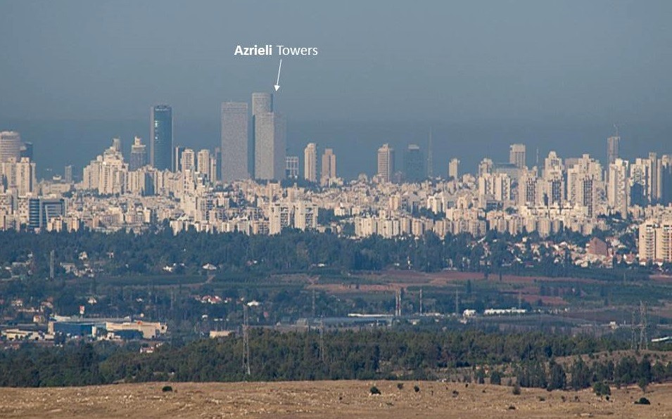
Photo: Hagai Nativ.
The clearly visible Azrieli Towers complex, an iconic feature of the central Tel Aviv skyline, houses a three-story shopping mall and recreation area, a thirteen-floor luxury hotel and numerous prestigious commercial companies, including many of the country’s leading law firms. And, oh yes, it is adjacent to the compound known as “Camp Rabin,” named after late Prime Minster Yitzhak Rabin, that comprises Israel’s Defense Ministry and the headquarters of the IDF General Staff…
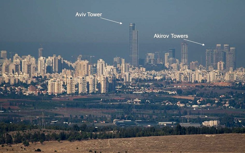
Photo: Hagai Nativ.
The Aviv Tower, located in the bustling vicinity of the Ramat Gan Diamond Exchange, is the tallest building in Israel, surrounded by popular restaurants, cafes, commercial enterprises and recreational facilities. The nearby Akirov Towers houses the former apartment of Ehud Barak, underscoring the stunning fact that there was once a line of sight between the residence of a defense minister and…“Palestine.”
Ben Gurion Airport — through binoculars of a Palestinian “intelligence officer”

Photo: Hagai Nativ.
This shot of the main terminal and runway at Ben Gurion Airport, as seen from the hills inside “Palestine,” underscores just how utterly exposed Israel’s only international airport would be to any hostile elements (renegade or otherwise) positioned on that elevated terrain.

Photo: Hagai Nativ.
For those familiar with Ben Gurion Airport, the long inclined corridor connecting the passport control stations with the large duty-free area is clearly visible from well within “Palestine.”
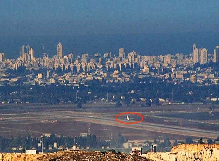
Photo: Hagai Nativ.
A tempting target: The unnerving sight of a plane taking off on the main runway, clearly visible and hopelessly exposed to any nefarious forces on the nearby hills inside “Palestine.”
Israel’s vulnerable power generating facilities – as seen from “Palestine”

Photo: Hagai Nativ.
The Orot-Rabin power station, near Hadera (also named after the late Yitzhak Rabin): The plant is currently Israel’s largest power station, with almost 20% of the Israel Electric Corporation’s total generating capacity. It is adjacent to Caesarea, a very upmarket locality, home to many of Israel’s rich and famous, including current Prime Minister Benjamin Netanyahu. This image was taken from the site of Homesh, one of the four communities destroyed during Ariel Sharon’s 2005 disengagement from Northern Samaria (which took place at the same time as the Gaza disengagement).
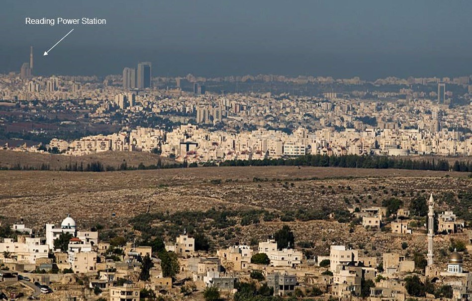
Photo: Israel Institute for Strategic Studies.
The Reading power station, supplying electricity to the Greater Tel Aviv district. The plant is located close to Tel Aviv port, Sde Dov airport and the upmarket neighborhoods of North Tel Aviv and Ramat Aviv, where Tel Aviv University is located. Taken from the vicinity of the Palestinian village of Rantis.
Terror Tunnels and Transportation
Photo: Israel Institute for Strategic Studies.
Taken near the Palestinian-Arab city of Qalqilya, a hotbed of terror in the past, this drone shot underscores the grave danger to traffic on the Trans-Israel highway (Route 6), connecting the north of the country with the south. In light of the threat of terror tunnels, mortar fire and rocket attacks emanating from Gaza, little imagination is required to visualize the consequences of evacuating areas abutting one of Israel’s major transportation arteries.
Pictures worth thousands of words
These photos convey the stark truths, expressed in the introductory excerpts above, as to the dire dangers a Palestinian state would pose to Israel’s “urban centers, its vulnerable airport…and traffic routes in the coastal plain…as well as to infrastructure installations vital for Israel’s existence…”
So, if you still support the two-state formula — beware. You just might get what you wish for.